Steel Plates of Rhine Map
Steel Plates of Rhine Map
Article from the IMCoS Journal.
Those who regularly read their IMCoS Journal will know that I have an interest in Rhine maps and have been collecting panorama views of the river for a number of years. Subsequent to my last article on Rhine panoramas I have come into possession of plates which were engraved for a map of the Rhine.
A Cologne map dealer has been very helpful in my search for Rhine panorama maps for a number of years and has also allowed me to record and photograph maps in her collection[i]. Some time ago she telephoned to say she had something that might interest me. When I discovered what she was offering, I simply could not resist! The parcel which finally arrived was of two steel plates which actually presented a map of the Rhine from Strasbourg as far as Rotterdam in the north. As well as the plates there was a printed copy of the map, possibly executed 20 years ago and obviously from the same plates.
As is usual for many Rhine maps designed for tourists up to 1900, the actual title of the map is given in three languages; as Rheinlauf von Strasburg bis Rotterdam; in French as Cours du Rhin de Strasbourg à Rotterdam; and in English as Course of the Rhine from Strasbourg to Rotterdam. The map itself shows the course of the Rhine plus a great many tributaries and (especially in the south) the main roads to the east and west of the river. In the north the rivers Maas, Alte (or old) Maas and the Leck are also shown. No railways are shown and Cologne Cathedral is portrayed with no steeple or towers.
The map is illustrated with 12 small vignette views of the various towns as seen from the river or a vantage point on a hill opposite. Each view (there are 3 on the left, 9 on the right bank) is only circa 25 mm high and is between 55 and 80 mm wide, the largest being Das Siebengebirg, an area southeast of Bonn near both Königswinter and Bad Honnef and consisting of some 40 “mountains” (highest ca. 460 meters) and hills of volcanic origin.
According to Professor Sattler, F W Delkeskamp, “the Master of Panoramas”, published his New Panorama of the Rhine in 1837 and this was reissued almost every year for the next 25 years. Its success was attributable to the introduction of illustrations in the margin, which made the panorama eminently suitable as a souvenir.[ii] After executing a relief map of Switzerland on nine sheets which was published by the Wilmans publishing house in 1830 Delkeskamp had turned his hand to improving his original Rhine maps of 1825-28. Probably during the summers of 1833-36 he drew illustrations of the scenic spots along the Rhine and these appeared as marginal illustrations in the New Panorama in the autumn of 1837.[iii]
The exciting thing about the steel plates, quite apart from the fact that to find the original plates to a map of the 1800s is itself unusual, is the fact that the map seems to be a contemporary of Delkeskamp´s introduction of river views. Cologne cathedral, or High Cathedral of St. Peter and Maria, is a roman catholic church and at 157 meters is, after the minster in Ulm, Germany´s second tallest and the third tallest church in the world. However, the towers were the final part of a building project begun over 600 years before (in 1248). Begun in 1842 the towers were completed in 1880 making it the world´s tallest building at the time (for only four years!). The vignette shown on the steel plates is an early view pre-dating the construction of these towers. Another pointer to the age of the steel plates is the absence of railways: Germany´s first steam railway was built between Fürth and Nuremberg (1835) but the first in the west of the country was the stretch Köln - Düren - Aachen - HerbesthaI, completed in 1843.
A search for the map on the internet discovered a guide not recorded by Sattler, Handbuch, für Reisende mit Dampfschiffen von London bis Straßburg. This volume was written by F.L. Lachenwitz, who had been K. Kreis-Sekretär and Inspector by the Rheinischen Dampfschiffahrts-Direkzion in Cologne. The work in question was written in 1836 after his retirement as Secretary and included a dedicatory page to the then President of the company: Dem Präsidenten der Verwaltung der Rheinischen Dampfschiffahrt, Herrn Heinrich Merkens, Ritter des rothen Adlerordens. It would seem that Lachenwitz published the book himself (Selbstverlag des Verfassers). The copy now in the author´s collection has very attractive cover illustrations of London (front) and of Strasburg, both surrounded by an intricate floral border decoration (and lithographed by Goebels Fréres in Cologne).
The book is a mine of information about the operations of the company and the history of steam boat operations on the river. It was not intended as a travel guide, although there are some references to sights, it was far more a non-fiction account of trade and tariffs[iv]. Some of it makes fascinating reading, e.g. we are told exactly what food and drinks are available on board the steamboats as well as how much these cost in the different restaurants on board. For example, we are informed that breakfast in the Pavilion is 60 cents, in the Large Kajute only 50 cents and in the bow Kajüte it costs 35 cents, each price being quoted in both the contemporary Prussian currency and in Dutch guilders.
The Handbuch, für Reisende mit Dampfschiffen von London bis Straßburg was published in 1836 and although Lachenwitz states in the prologue that he expects to bring the book up to date with reissues no further edition is known. The book contents do not call for a map, so later insertion is possible. However, the indicators suggest that the steel plates were ready in a period between 1836 and 1842 and if the earlier date is correct this would predate Delkeskamp´s New Panorama by one year. However, no contemporary printed copy of the map as found on the plates is known, only the lithograph version (another copy in cardboard covers is known). Were the steel plates ever used to make printed copies or were they immediately turned over to the lithographer who used them to produce images on stone for lithographic printing? The vignettes may have caused the lithographer some problems but why include a new scene? The plates pose a tantalising enigma.
History of the Rhine Steam Ship Company - Rheinischen Dampfschiffahrt
Although Wager and Watt had attempted to start a steam ship enterprise on the Rhine with little success it was the Dutch who really initiated long-term operations on the river. After Biart Oreille & Co. had failed to set up regular operations between Antwerp and Cologne in the Hoffnung von Antwerpen it was left to the company of Van Vollenhoven Dutilh & Company to lead the way. The company was founded in 1822 and their success was immediate with a share-holding company being set up within a short time with the permission of the King of the Netherlands and the Neederlandsche Stoomboot-Maatschappij was created. The (royal) chamber of commerce in Cologne was so excited at the idea that they bought as many shares in the company as they could and by 1825 there was a regular service between Cologne and Rotterdam. Connection was also made with trade to and from London.
By 1825 this enterprise was operating a connection to and from London and Cologne and had a number of ships at their disposal including the Batavier which operated between London and Rotterdam; The Stadt Düsseldorf and Prinz Friedrich von Preussen which sailed from Rotterdam and Düsseldorf; and at least five ships sailing between Cologne and Rotterdam, including Agrippina, Ludwig, Stadt Nimwegen, Stadt Köln and Zeeuw.
In 1825 agreement was reached between the Dutch shipping company and the chamber of commerce that the Dutch should operate all ships from Cologne downstream and that the Preussisch-Rheinische Dampfschiffahrt should operate traffic upstream. On 15th September 1825 a test passage was undertaken on the ship der Rhein. The passage to Strasbourg took 74 hours and 28 minutes: the return journey only taking 27 hours and 2 minutes.
Regular connections between Mainz and Cologne began on 1st May 1827 and during the season a total of 97 journeys took place between the two cities carrying 7393 persons upstream and 11231 down the river. A total of 57135 Zentner[v] of goods were additionally carried. On 11th September there was a slight accident. The Concordia was drawn against one of the rocks – today known as Concordia Rock. This led to subsequent widening of the channel.
1828 saw a rise in the numbers of people (33,352 in both directions) and goods (83,292 Zentner) as well as the carriage of wagons (403) and horses (55). This increase continued almost unabated and in 1835, between 12th February and the end of the season on 13th November a total of 113,447 passengers, 1173 carriages, 149 horses, 589 dogs and 181,075 Zentner of goods had been transported. Together with services from Strasbourg this provided travellers with the possibility of journeying from there to London in four days. This journey would have cost a passenger travelling in the Pavilion class £6 1s 10p or just £2 0s 0p travelling in the Matrosen-Raum.
The Rules and Regulations concerning carriage were drawn up on 20th May 1827 and consisted of 1. (expeditions-komptoiren and) Fares and belongings and embarking and disembarking; 2. Duties of the civil servants to the passengers; 3.Duties of passengers. The third section makes interesting reading: rule 35 – besides not being allowed to bring non-declared goods on board, items which might annoy other travellers were also prohibited such as powder (gunpowder?), vitriolic acid, sulphuric acid, or soot, down (feathers), asafedita (also known as devil's dung or stinking gum), leather glue, limburger cheese, old clothes and rags! Rule 44 forbade smoking in the inside rooms of 1st and 2nd class but smoking with covered pipe (presumably clay pipe with small lid) was allowed for 3rd and 4th class (page 85).
The first class passengers could be served at meals by their own personnel, otherwise classes 1 to 3 could demand service: the 4th class were not eligible for table service! (rule 52).
Finally section 4, General Regulations, included common sense rules such as the Administration will not allow more passengers to travel as the ship can carry; and in the event of unavoidable delay passengers should be brought to their destination as soon as possible at the cost of the shipping company.
In addition to the above rules and regulations there were strict guidelines concerning the restaurants and the meals and stipulations as to how much each beverage or meal should cost in each class. For example, the following had to be offered at breakfast: chocolate, coffee, tea, bouillon, eggs, meat, butter, cheese and sufficient fresh, best, white, grey or black bread as required by the passengers. The midday meal in first class (Pavilion) had to include a strong meat soup; roast beef with potatoes and gravy or beef with gravy and appropriate side dishes (to be changed daily); two vegetables (besides potatoes) with two side dishes, of which one had to be meat; two ragouts according to season; two intermediate courses, one being sweet; two roasts with salad; jam; dessert. Price – one thaler per person without wine.
The maps and plates
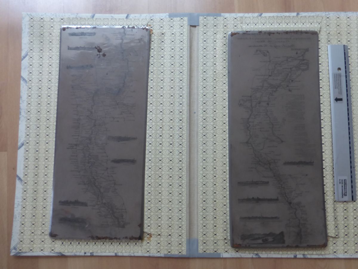
The title of the folding map contained in this volume is the same as that of the steel plates, i.e. Rheinlauf von Strasburg bis Rotterdam and is in three languages (English centrally below, German (left) and French (right). Below Herzogenbusch (sic) on the steel plates there is a note on Booking Offices (in 3 languages), together with a note on coach connections (also in 3 languages) and above a view of Krefeld. There is no border and the steel plates are each 450 x 200 mm with the engraved area approx. 870 x 180 mm for the complete map.
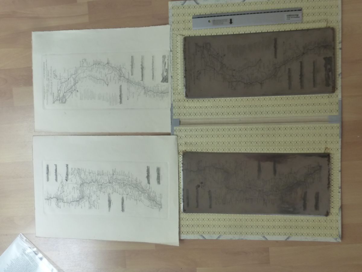
The handbook map shows the same course of the Rhine but with only two small vignette views of Das Siebengebirg (sic). Whereas the steel plates would have been used for intaglio printing, this map is a lithograph and has the printer´s signature in two languages: Lithogr. Institut der Gebr. Kehr & Niesse in Cöln and Lithographie des fréres Kehr & Niessen á Cologne.
The note on Booking Offices (in 3 languages) is between Worms and Speyer (left) and the note on coach connections (3 languages) is placed between Karlsruhe and Srtrasbourg (right). There is now a five-line border and the area at Dinslaken is missing as is the area west of Venlo (north of Jülich) and small area south of Weilburg (which is also missing). The approx. size of the lithographed area is 895 x 160 mm.
As mentioned there are only two views: Siebenburgen found on the steel plate; and the other is different (and slightly larger than the others). The various notes are also in different locations on the map compared to the plates. The signatures are new. Inspection of the print taken from the plates and the map in Lachenwitz indicate that the plate was produced earlier than the printed lithograph. This would make sense as several publishers took maps executed first on copper and later transferred them to stone for lithographic printing, George W Bacon being a good example in the UK.
The map found in the handbook has been pasted into the inside cover (and was not bound or glued into the folds) so may have been added later. Other copies of the map have been found, but folding into covers. There is no evidence of excision from other covers, but also no reference to a map on title page or introduction to the handbook. So, although the book is dated 1836, the engraved plates could be older, but not later than 1842 (based on Cologne Cathedral and railway information). A date of 1836 for the plates is certainly not unreasonable. The steel plates are in very good condition and have been examined with the possible future intention of running a few prints off them.
[i] I would like to thank Mrs Angelika Herzogenrath at Goyert Gallery in Cologne for her help and assistance.
[ii] Professor Alfred Sattler in the list of exhibits which accompanied the RHEINPANORAMEN Reisehilfen und Souvenirs exhibition at the Universitäts- und Stadtbibliothek Köln from 7 May to 24th July 1993.
[iii] Professor Alfred Sattler in the catalogue which accompanied the RHEINPANORAMEN Reisehilfen und Souvenirs exhibition, page 30.
[iv] Geschichte der Dampfschiffahrt auf dem Rheine – Tarife für Passagiere, Wagen, Pferde und Hunde – Tarife für Güterfrachten – Restaurazion auf den Rheinischen Schiffen bzw. Niederländischen Schiffen – Nachrichten (Informationen) über die Benannten Orte
[v] Although it varied from area to area a zentner was approximately 50 kilogrammes and was officially set at this level from 1st January 1840 for customs purposes.